Podcast: Play in new window | Download (Duration: 30:46 — 38.1MB)
Subscribe: Apple Podcasts | Spotify | Amazon Music | Android | Pandora | iHeartRadio | JioSaavn | Podcast Index | Email | TuneIn | RSS | More
By Davy Crockett

This is the third part of the rim-to-rim series. Read first Part 1 and Part 2
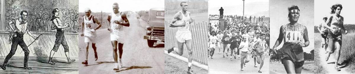
 As the Grand Canyon entered the 1940s, the corridor trails were in place along with the Black Bridge across the Colorado River, making rim-to-rim travel on foot possible. By the early 1960s, a few daring athletes were hiking or running rim to rim in a day and even a few completing double crossings in a day. Credit goes to Pete Cowgill (1925-2019) and his Southern Arizona Hiking Club from Tucson, Arizona, who demonstrated to all that crossing the Canyon on foot in a day was not only possible but was an amazing adventure.
The Boy Scouts in Arizona started to offer rim-to-rim patches to those who completed the hike. A rim-to-rim-to-rim patch appeared in 1963. Publicity for the patches were being published in national scouting magazines. That year a fifty-mile hike craze was also burning throughout the country attracting more hikers to the Canyon. Arizona State College in Flagstaff started to organize large rim-to-river and back hikes.
Warnings were offered by the wise: “It is more rugged than anything you have every pictured. Despite its famed beauty, the canyon is a natural killer and hardly a year goes by that it doesn’t claim at least one life in some way.”
In 1963, visitors topped 1.5 million and serious growing pains were felt at Grand Canyon Village with traffic, crowded lodging, and strained Park services. More development was needed but the big limitation was water. The quest for water would result pausing in rim-to-rim travel for more than five years.
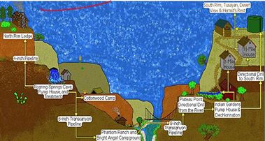
The Trans-Canyon Water Pipeline
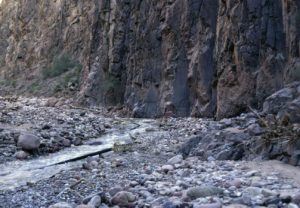
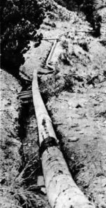
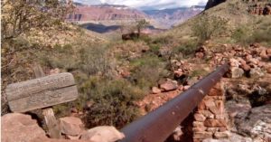 As you hike or run rim to rim, you see can see at times pipes and other indications that there is a pipeline buried under the North Kaibab and other trails. This is the trans-canyon pipeline which is the lifeblood for the South Rim and other locations along the way that supplies the water for your adventure. There is significant history behind the creation of this pipeline and several people even lost their lives during construction. As you travel rim to rim you should observe and know what once took place on the trails you travel including a massive 1966 flood, the most destructive event to the corridor inner canyon in recorded history.
South Rim
Obtaining water for both Grand Canyon rims has always been a challenge. Since before 1900, on the South Rim, water was hauled in from 18 miles or more. By 1919, the Santa Fe railroad hauled up to 100,000 gallons per day to Grand Canyon Village. In 1926 a reclamation plant was built to reclaim water for non-drinking uses which helped some. Deep wells did not exist because of all the sedimentary rock layers. Rainwater would just run out of the rock and down into the Canyon.
In 1931 construction of a water system began at Indian Garden to pump water up to the South Rim. A cable tramway was constructed from the rim to about a mile above the Garden which was used to bring down a five-ton tractor to help with construction. The tram was removed in 1932 but signs of it still be seen 50 yards northeast of the 3-mile rest house. By 1934, the pump was in operation bringing about 150,000 gallons per day 3,200 feet up a six-inch pipe to the South Rim. The water was still supplemented during the summer with water tank train cars and million-gallon storage tanks. Portions of this pipeline are still visible.
North Rim
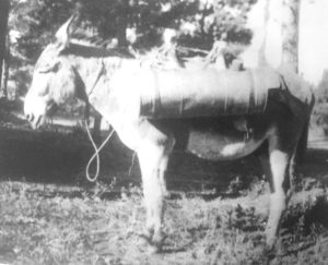 Over on the North Rim, there were a few springs a couple hundred feet below the rim. During the early 1920s. young Robert Wylie McGee would make daily trips to a spring to haul water by burro to Wiley Way Camp. He wrote, “The spring was about 5/8th of a mile, down in the mouth of a draw, west of the camp. The climb was probably a 200-foot change in elevation. Brighty (the burro) and I would make about four to seven trips daily. I filled the cans out of a wood barrel that the spring dribbled into using a bucket and a funnel.” The water would be dumped into a tub at the top near the kitchen.
With all the visitors coming to the North Rim, the few springs near the top did not provide enough water. By 1928 a power plant was built below Roaring Springs to generate power for a pumping station to lift water 3,870 feet to the rim through 12,700 feet of three-inch steel pipe, some of which can still be seen today. The heavy machinery to construct the plant and pump station was lowered on the tramway that had been built to bring material down to build the North Kaibab Trail.
Plans for the trans-canyon pipeline
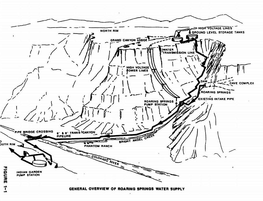
 By 1960, with more than one million Park visitors each year, it was clear that a better water solution was needed. In 1963, a plan was conceived to build a 13.4-mile trans-canyon water line to transport about a half million gallons per day from Roaring Springs across the Canyon. “The pipeline will take water from Roaring Springs on the north side of the Grand Canyon, down Bright Angel Canyon, across the Colorado River suspended from a pedestrian walkway, and up out of the 1,500-foot-deep inner gorge to the pumping station at Indian Garden, 3,200 feet below the South Rim, all gravity flow. From this point, it will be pumped to the Grand Canyon Village and stored in reservoirs.”
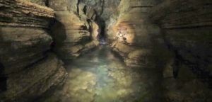
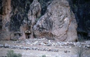
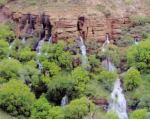 From the North Kaibab Trail, you can look up and see water coming out of caves. A series of five rock dams were built inside the cave complex in the 1920s to collect water.
The cave’s average flow of water is 5.8 million gallons per day. The plan was for seventeen percent of the spring water to be diverted into two intake pipes. The rest of the water would free-flow out the east cave entrance down to Roaring Springs Creek. At the Roaring Springs pump house, sediment would be removed, and chlorine gas is used to purify the water. Some water would be pumped up to the North Rim and up to 500,000 gallons of water per day travel by gravity all the way to a tank at Indian Garden on the south side of the Colorado River. At times not to disturb visitors, the Indian Garden pumps would push the water the rest of the way up to the South Rim to storage tanks.
“The pipeline must be laid under a three-foot-wide horse trail. Strict rules to preserve the beauty and natural scenery of the canyon specify that no plant or rock outside the trail can be disturbed. And when the job is finished the hikers and mule riders should be able to travel the trail without knowing the pipeline is there.”
Construction begins
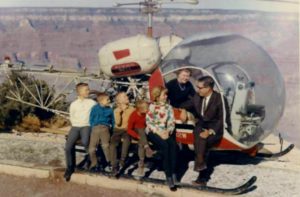
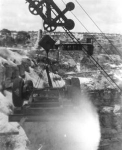
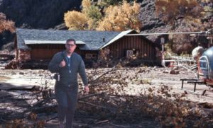
A $2,277,557 contract was awarded to the Halvorson-Lents Construction company of Seattle, Washington, a company that had developed the reputation of undertaking risking jobs few other would even consider taking on. The construction was led by Elling Halvorson, age 33. The company had recently built a communications facility in the Sierra, well above Echo Summit Pass, high above Lake Tahoe. Halvorson did extensive exploring along the route designed by the Park service and successfully won a low, but realistic bid for the work. He moved his wife and six children to Grand Canyon Village.
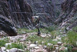
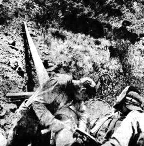
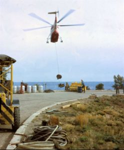
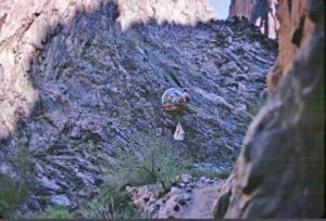
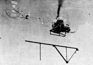
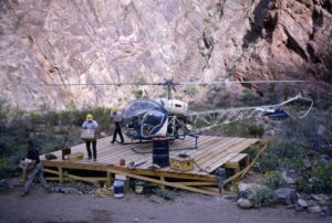 Work began in March, 1965. A camp was built with bunkhouses and a cook house. The crew of about 50 workers stayed in the canyon all week and then went home on weekends. Instead of using mules, they would use up to ten helicopters and eventually log 7,500 flights and 25,000 total flying hours. They worked during the hot summer when temperatures soared above 100 degrees. Their workdays started at dawn, and each man carried two gallons of water with them as they worked, and at times would cool off in Bright Angel Creek.
The park announced that North Kaibab Trail would be closed during the construction. “The closure has been found necessary because of the extremely hazardous conditions prevailing during the present phase of construction between Roaring Springs and Phantom Ranch. Large section of the trail must be excavated.”
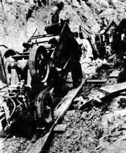
Digging ditches
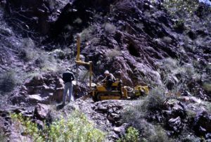
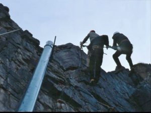
Construction men called it one of the most difficult pipeline jobs every undertaken because big machinery could not be used. Special small machinery that could fit on the six-foot-wide trail needed to be used. One was a crawler-type tractor with a mounted compressor and 1.5 inch drill. Most of the 18-inch ditches for the pipeline needed to be blasted out of solid rock. Dwarf backhoes, a tiny bulldozer and a rock crusher mounted on a Jeep chassis were used.

“With the tiny backhoe, the loosened rock and dirt is dug out and loaded onto a conveyor that carries it to a small crusher that reduces it to about one-inch size. This crushed material then is dropped back into the trench, filling it so that foot traffic and vehicles can move over the trail until it is time to lay the pipe. Dirt or crushed material cannot be piled outside the trail under the no-disturbance rules.” .
 The trenching pace was slow, from only 25-140 feet per day. Blasting was a challenge. Halvorson wrote, “Even our top professionals found it a challenge to blast mile after mile of the pipeline trench. The delicate operation required the well-skilled technicians to avoid harming the trail wall. We succeeded however, in preserving the trail’s integrity. The helicopter pipe-laying method often made for very dangerous flying. Many times the trail was located next to a sheer cliff wall on one side not far from another sheer cliff wall on the other side. That meant our pilot, descending into a box canyon was allowed no errors.”
Laying pipes
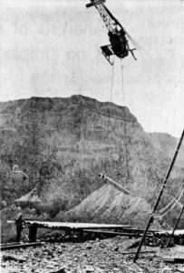
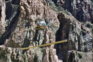
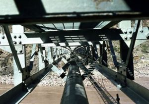
Helicopters carried in the welding equipment and crew. Fifty-foot lengths of aluminum pipe were carried, two at a time under the helicopters from a staging area at the head of Kaibab Trail on the South Rim. Twists and turns happened about every 12 feet along the pipeline route so the bending station operated daily at Plateau Point on the 50-foot pipe segments. Measurements for the bends were sent up two days in advance. They used aluminum pipe because it was easier to bend.
Helicopters brought down all the materials to various staging locations along the North Kaibab Trail, River Trail, Plateau Point Trail, and Bright Angel Trail. It was said to be a spectacular thing to watch.
When it came time to lay the pipe, they were welded into place, and a small backhoe moved in and cleaned out the crushed material.
Hiking during construction
In February 1966 the Park announced closure to trails for at least six months. Bright Angel Trail was open to Indian Garden, but the Plateau Point Trail was closed. The River Trail was closed and also the North Kaibab Trail through The Box. Rim to Rim hikes were not allowed.
 However, some people disregarded the “trail closed” signs and hiked down from the North Rim. One group, early in 1966 descended and built a campfire. The fire got away and turned in to a small very destructive forest fire that raced up a canyon slope. The flames melted pipe laying on the ground to liquid. Others got into trouble that year. Two visitors took two low-geared motor scooters down Bright Angel Trail and spooked a mule train. They were fined $50.
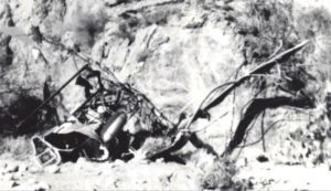
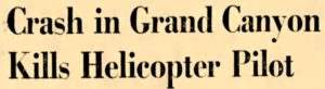 On April 12, 1966, a Halvorson-Lents Construction company helicopter crashed about four miles north of Phantom Ranch, killing the pilot, Jack Pittman, 47, of Los Angeles, a retired marine, and seriously injuring two other men.
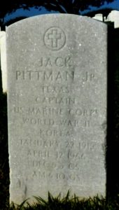 Dan Cockrum, one of the National Park Service civil engineer inspectors recalled, “The helicopter with pilot and two Navajo workers aboard lifted off from the helipad at the camp, traveled a very short distance before it lost power to its tail rotor and without enough altitude and forward speed spun into the ground before the pilot could take any effective corrective maneuver. The impact was so powerful the single-seat belt shared by the two workers failed and they were thrown forward through the helicopter’s canopy and survived with major broken bones. The pilot’s seat belt held but since there was no strap across his chest his head smashed into the joystick due to the force of the impact, mortally injuring him. Personnel at the camp were able to rush to the scene and remove the injured before the wreckage burst into flames but the pilot died at the scene as a result of his massive head wounds. The two workers were helicoptered out and were treated in the Flagstaff Hospital where they eventually recovered.”
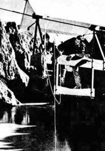
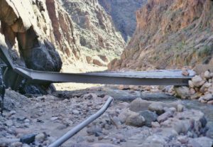
Silver Bridge
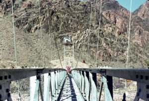 A new trail on the north bank of the Colorado River was built to the site of a new 522-foot Silver Bridge that would take the pipeline across the Colorado River and used by pedestrians. The towers on each bank are 61 feet tall. The huge cables were brought down by helicopter to a Phantom Ranch staging area. The cables were the heaviest single loads for the entire project.
 From the bridge, the pipeline continues along the sandbar and then joins the River Trail in a trench to Pipe Creek. It continues under the trail for several hundred feet and then turns right and up the canyon wall for 1,600 feet to Plateau Point, and then goes along that trail. An electrical line went along with the pipeline from the South Rim to Phantom Ranch, bringing electricity down for the first time, eliminating the need for generators.
By December 1966 the pipeline and Silver Bridge neared completion and were awaiting inspection.
The Burnetts
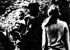 There were people who lived down in the Grand Canyon. In 1963 Bill Burnett moved his wife, Molly, and his ten-month old son, “Miggy”, to Phantom Ranch. He was employed by the U.S. Geological Survey and measured the Colorado River flow each day using the tram built in the 1920s that crossed over the river. The Burnetts lived in a USGS residence that had been built south of Phantom Ranch, close to the river.
 Life was quiet and simple for the Burnetts. The house used a generator for electricity and butane gas for hot water and the refrigerator. Groceries would come down on the Phantom Ranch supply mule train. Each day Bill would head along the Kaibab trail, hike up the river, board the tram and use gadgets to measure the speed, depth, temperature, and take samples of the water for silt estimates. He then went back home to work with his graphs and reports.
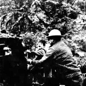
The Brunetts were still living in the canyon three years later, in 1966. Their only permanent neighbor was Ken Smith, a Park Service employee who maintained the trails and campground. Three-year-old Miggy would play outside the house watching deer, squirrels, mice, and the passing mules. The little boy would also greet hikers who came by. On summer nights the Burnetts would lie on cots outside and enjoy the stars. The Burdett said that they “much prefer the sounds and the fragrance of the outdoors to the clatter of traffic and the gas fumes of city streets.”
With the pipeline work going on, helicopters were frequent and would land a little downriver. “The workmen know Miggy and give him rides on their machines or scooters.” They would reach into their lunches to give him a cookie or an orange. Miggy would play with a toy helicopter of his own. In 2020, Bill Burnett was 83 and living in Sedona, Arizona.
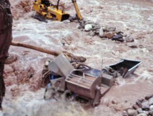
1966 Flood
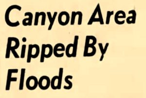 December 1966 opened with a terrible storm that hit the west coast and then raged across America. The storm caused flooding throughout California, extensive property damage, collapsed bridges, blocked roads, and caused some deaths. About 700 California homes had to be evacuated. Flash floods in southern Nevada required helicopter rescue of 55 boys and counselors of a youth camp. Southern Utah’s Virgin River flooded terribly from Zion National Park.
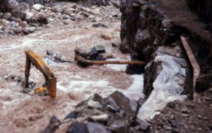
 The North Rim had very little snow on the ground, only about 4-6 inches. At noon on December 3rd, terrifying clouds began to roll toward the Canyon. One man said, “It looked like the devil was in the sky.” Because it was a Saturday, the construction crew was all out of the Canyon. At about 1 a.m., downpours descended on a 100-square-mile area on the North Rim. About ten inches of rain fell in six hours and it continued for three days with another 3-4 inches. A massive flood raged down Bright Angel Canyon. It was thought to be a 1,000-year flood because Native American ruins nearby dating back some 1,000 years were swept away.
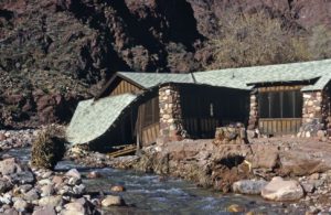
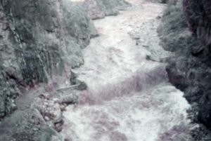
The flood struck Phantom Ranch “with the noise of a dozen locomotives” heard by the employee of the U.S. Geological Survey who lived at Phantom Ranch. He feared for his life and explained, “The big boulders that are in the bottom of the canyon must all be touching one another. The vibration of the flood was transmitted through them, and the ground itself trembles under your feet. It wasn’t just the size of the flood, but the duration of it. It rose up and didn’t drop an inch for three days.” Phantom Ranch became isolated, leaving a few people who were there marooned for several days until the floodwater subsided.
 The destruction was significant. “Most of the mule corral and its massive stone walls went down the creek. Hundred-year-old cottonwoods fell by the score. Phantom’s sewer system, the irrigation works, the wire-and-rock flood diversions all were swept away. The flood gripped the bunkhouse and dragged it. Up and down Bright Angel Canyon, the damage was colossal. The trail to the North Rim was severed by cuts 10 feet deep. Two-thirds of the campground below Phantom Ranch, the very earth and the trees and the campsites, was eaten away. New aluminum bridges were ruined. The flood uncovered the pipeline, broke them, and twisted them.”
The flood washed away restrooms, the sewer system and various other structures that had stood for nearly 60 years. Bright Angel Canyon and many of its tributaries were now ten feet deeper than before the flood. Boulders weighing up to six tons, earth, and rocks slid down the Canyon cliffs. It caused an estimated $2 million in damage.
The aftermath
 As soon as possible, the contractors and Park officials went to survey the damage. “When the water at last receded, the enormity of the losses could be seen. Thousands upon thousands of cubic yards of silt and rock were dumped in a delta where Bright Angel joins the Colorado. Those familiar with Phantom Ranch surely will be saddened by what has occurred. The sandy creek banks, the friendly shade, the flashing trout, have all but disappeared and vast flats have become sterile fields of scoured boulders. Nowhere is there visible a more convincing demonstration of the cutting edge of angry water, where in a finger snap of geologic time, a little creek moved a mountain.”
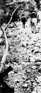
 It was reported, “At least 40 percent of the pipeline was destroyed including 5 miles of North Kaibab Trail and several of its bridges spanning Bright Angel Creek. The contractor lost all his construction equipment. The flood severely damaged or destroyed Park facilities.” At Roaring Springs, 2 1/2 feet of water ran through the pump house and the powerhouse just downstream, was destroyed.
The crash
 Once the skies cleared on the morning December 5,1966, Halvorson rushed out early to survey the damage. He said, “I saw destruction everywhere. Cliffs, some 200 to 300 feet high, had collapsed. Side trails had been wiped out, along with six of the seven bridges we’d built over the creek. Dozens of segments of the once-buried pipe had been reduced to twisted aluminum. Even from the air I could see we’d lost from 8-10 miles of pipeline.” Gushing from below The Box, he could see millions of gallons of water gushing from cracks in the cliff wall across an expanse of nearly one and a half miles. He flew back to the headquarters near Yaki Point, gathered his men, explained the situation and sadly told them that they were all terminated and would receive their final paycheck.
 Havlorson recalled, “The mood of the moment I finished my announcement was awful. Everyone on the job was out of work now, including me. I saw financial ruin coming at me head-on. We still owed bank loans on some of our equipment, machinery that was uninsured. We hadn’t bothered purchasing insurance on it because we removed it every night to a point higher than the 100-year flood plain. Also, park service had completely closed the trail during our construction project, so, with no tourists around, vandalism wasn’t a risk. Our resulting loss on remaining bank obligations for equipment alone was half a million dollars.”
A week later, on December 12, Halvorson returned with a couple managers to assess the damage more closely. They took off from Yaki Point flew to the mouth of Bright Angel Creek at the Colorado River. He said, “I saw the exhaust stack of a Caterpillar crawler tractor sticking up from the water like a periscope. It had tumbled downstream about one and a half miles.” They landed to examine it. He noticed that cottonwood trees that had been as tall as a 10-story buildings had been swept away.
They lifted off and he told the pilot to fly low and slow so they could photograph the damage. He wrote, “We few 40 miles an hour at 75 to 100 feet above the canyon floor. Suddenly we slammed into an antenna wire, formerly hidden by cottonwood branches, that had been put there by the Civilian Conservation Corps. The wire snapped and whipped around the helicopter. The pilot tried to land but the wire ripped off the tail rotor and blades.” They spun out of control and crashed on the rocky shore below.
Halvorson was seriously injured and thought he was dying. The others received only minor injuries. The U.S. Geological Survey employee witnessed and even filmed the crash. He rushed to his house only 100 yards from the crash and telephoned the South Rim for help. Another helicopter rushed down and took Halvorson to the hospital. His entire chest had been crushed with 18 broken ribs. He also had a punctured lung, and a broken leg. He needed to be taken to the hospital in Flagstaff, but no ambulance was available, so he was transported in a hearse bearing the name “Flagstaff Mortuary” on the back. He quickly recovered and was walking again in two weeks.
Reconstruction
 Reconstruction of the pipeline did not immediately start because of legal disputes regarding who should pay, the contractor or the Park. The government issued a stop work order. No public travel was permitted to Phantom Ranch for two months. During the next year, many repairs were made to Phantom Ranch. In May 1967, Bright Angel Creek was restocked with 15,000 brown and rainbow trout using a helicopter. It took just 40 minutes.
In April, 1968, an agreement was finally reached for the Park to provide $1.6 million of additional funds to complete the pipeline. Work started up again in August 1968. North Kaibab trail was still closed. Thirty-five men were flown in and out of the canyon by helicopters. Because most of the original North Kaibab trail had been swept away in Bright Angel Canyon, they could rebuild a much safer trail and did not have the same restrictions for skinny machines. They also didn’t need to crush rock, there was plenty in the stream bed.
 About five and a half miles of the original pipeline survived, but they had to restore about eight and a half miles. Unfortunately a fire broke out one day in their camp kitchen. It spread on wooden boardwalks to other structures. All the cook could do was climb a hill and watch it all burn down. Rather than rebuild the camp, they decided to fly the workers in and out of the canyon every day.
 The upper portions of the North Kaibab trail remained closed until 1969 and the lower trail did not open until 1971.
Construction this time was more serious and sturdier, taking more time. A bulldozer, front-end loader, three tractors, several dump trucks, ten pickup trucks, and a large trailer-mounted air compressor were used to dig trenches, bury the pipe, and smooth out the new trail. Workers were moved up and down the trail on motorcycles. Design changes were made to lift the pipeline and trail higher along Bright Angel Creek in The Box and near Cottonwood Campground.
More Deaths

 On July 29, 1969 another deadly helicopter crash occurred. Park rangers said that near Yaki Point, a fuel tank, suspended on a cable beneath the helicopter, hit the side of the wall and forced the craft down before the pilot could release the load. It crashed 200 feet below the rim. The pilot, Joe Savage, 31, died, and his 18-year-old brother, James was critically injured, and burned over nearly 90 percent of his body. A rescue team led by a ranger rushed to the site and young Savage was taken to the Grand Canyon Hospital and then flown to a Phoenix burn center. Sadly he died a few days later. Another helicopter tragedy also occurred that week. Two Maryland sightseers and a pilot were also killed when their craft crashed on the Kaibab Plateau.
 On December 15, 1969, yet another crash occurred. Arthur Ranger, 45, of Silver City, New Mexico, the chief pilot and employee of the construction company, was flying alone and crashed in upper Bright Angel Creek near the North Rim. Another pilot discovered the crash only minutes later when he heard Ranger’s radio go dead. The two were working together on a supply assignment. Ranger was pronounced dead at the scene. It was determined that a cable used to haul pipe was left dangling and became entangled in the tail rotor.
Earlier in October, three pipeline workers were injured when their helicopter crashed on takeoff at Yaki Point. On average, three helicopters were in constant use each day for six hours. Through all the years of pipeline construction, seven men were killed in crashes.
Bright Angel Creek Bridge Construction
 Three aluminum bridges that were mostly destroyed by the flood were replaced by steel truss bridges to support the pipeline. They were built 15 feet above the creek. Two were 70 feet long and the other 100 feet long. They were colored to blend in with the natural cliffs.
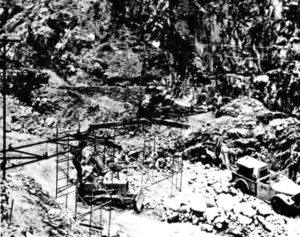 A 35-ton D-7 Caterpillar tractor was brought down in pieces, taking five trips. “The logistics involved in erecting them a mile down in the prehistoric void was a dramatic and superlative feat of construction expertise, using modern techniques of materials handling.” The temperature differences of 35 degrees from top to bottom made helicopter travel challenging. In all, 16,000 pounds of bridge sections and 500,000 pounds of mechanical equipment were transported to bridge construction sites.
The crew also relocated Bright Angel Creek in certain places, especially near Phantom Ranch. Gabion baskets with wire mesh around rocks were used to prevent erosion, still seen today.
Pipeline Completion
 Engineers conducted their final inspection on July 24, 1970 and the Park dedicated the pipeline in a ceremony the following day. The total project cost about $5 million. The workers called it the “mule trail pipeline” and “the crookedest pipeline in the world.” There were more than 2,000 bends in the line. The construction project was recognized as the largest helicopter job even performed up to that time in the United States. Elling Halvorson purchased Grand Canyon Airlines and went into the tour business for the decades to come. In 2020, he was 88 and living in Woodinville, Washington.
The pipeline was put into operation and was capable of delivering up to 500,000 gallons of water to the South Rim per day. This was equivalent of more than 20 railroad tank cars. It was written, “The thirst of Grand Canyon has been quenched.”
 The water system had problems over the next few years. “The Park’s operations staff developed an understanding of its character, and soon learned that occasional leaks occurred typically at welded joints and in the dense series of
pipe bends through The Box.”
There were a few minor breaks in the line from rockslides. In July 1971, a wall of water again rushed down Bright Angel Creek and stranded hikers from Phantom Ranch on the wrong side of a washout area. They had to spend the night out in the canyon. Rangers came to the rescue the next day, strung ropes across the rain-swollen creek, and helped the hikers on their way. The washout exposed a 60-foot section of the water line about a mile above Phantom Ranch.
The most serious problem was in 1973 when there was a large amount sediment in the water at Roaring Springs because of a heavy runoff year. The pumps could not run at full capacity because of the silt that caused the units to overheat. Water needed to be recirculated to slow the flow down. Normally 480 gallons per minute would flow but it was reduced to 140 and the South Rim experienced a water shortage during the summer.
Grand Canyon Rim-to-Rim Series
- 46: Grand Canyon Rim-to-Rim History – Part 1 (1890-1928)
- 47: Grand Canyon Rim-to-Rim History – Part 2 (1928-1964)
- 48: Grand Canyon Rim-to-Rim History – Part 3 (1964-1972)
- 49: Grand Canyon Rim-to-Rim History – Part 4: Aiken Family
- 50: Grand Canyon Rim-to-Rim History – Part 5: The Races
- 135: Grand Canyon Rim-to-Rim History – Part 6: Early Guides
- 136: Grand Canyon Rim-to-Rim History – Part 7: Prof Cureton
- 137: Grand Canyon Rim-to-Rim History – Part 8: Kolb Brothers
- 138: Grand Canyon Rim-to-Rim History – Part 9: Phantom Ranch
Sources:
- Martha McKee Krueger, Bobby, Brighty, and the Wylie Way
- Arizona Republic (Phoenix, Arizona), Jul 17, 1963, Aug 9, 1965, Feb 22, 27, Apr 13, Dec 8, 17, 1966, Jan 20, Apr 19, May 28, 1967, Aug 5, 1969, Jul 25, 1970, Jun 19, 1973
- Arizona Daily Sun (Flagstaff, Arizona), Jun 27, 1963, Dec 15, 1966, May 23, 1968, Nov 24, 1968, Jun 30, 1969, Dec 16, 1969, Jun 11, 2008, Feb 9 2009
- Arizona Daily Star (Tucson, Arizona), June 10, 1960, June 18, 1961, Jun 21, 1964, , Jul 24, 1970, May 19, 1979, May 4, 1990, Jun 28, 1992, Dec 6, 2007
- Statesman Journal (Salem, Oregon), Aug 8, 1965
- Tucson Daily Citizen (Arizona), Jul 27, 1966, Jul 28, 1970, Jul 21 1971
- Michael P. Ghiglieri and Thomas M. Myers, Over the Edge: Death in the Grand Canyon
- Halvorson, Elling. Detours to Destiny: A Memoir
- Wayne Ranney, “Early Musings”
- Trans-Canyon Water Pipeline